Search This Blog

Showing posts with label British. Show all posts

Avchitgad Fort near Roha in Raigad district in Maharashtra

Monday, December 4, 2017

It's been a long time, since I had been on a trek. By trek  I meant climbed a fort, as of lately I have been visiting land forts around Maharashtra, so I decided to do some easy treks between Roha and Mahad in Maharashtra.
Maha Darwaza to enter Avchitgad Fort near Roha in Raigad district in Maharashtra
I asked Manohar and Dominic, my usual partners in crime and they readily agreed to join in.

As I was the man in charge of the itinerary, we decided to visit Avchitgad Fort, Birwadi Fort, Ghosalgad Fort, Kuda Caves, Tala Fort, Mangad Fort and Surgad Fort in a three day trip.
The well enroute Avchitgad Fort near Roha in Raigad district in Maharashtra
It had not been raining for the last couple of days, so we were hoping that it would be dry and sunny on the trip. Fingers crossed.
There are two ways of reaching Avchitad Fort. The directions to the fort are tagged on Google Maps. One can either travel via the Mumbai Pune Expressway (Toll Road) like we did, exit at Khalapur and from there crossed, Durshet, Pali, Bhise and finally Medhe the base village for Avchitgad Fort.

The other route is the Old Goa route, from Panvel, cross the Karnala Fort, Pen Nagothane , Bhise and finally Medhe the base village for Avchitgad Fort.
Map of Avchitgad Fort near Roha in Raigad district in Maharashtra
We reached Medhe Village around 10:15 AM. The reason why it took us time, is because we braked for breakfast on the way. Parked the car near the temple. Inquired with the locals regarding the directions to the fort.

It was a sunny day, we decided to carry 2 liters water to quench our thirst, after all we were climbing hill forts after a very long break.
View of the land, enroute Avchitgad Fort near Roha in Raigad district in Maharashtra
History states that Avchitgad Fort was built by the Shilahar Dynasty. It was later taken over by the Nizam of Ahmednagar, Shivaji Maharaj, the Peshwas and finally the British.

Though it was not raining that they, it might have rained before as the soil was damp.

We crossed two wells made of black stone, the water in it is not portable though. The trek to the fort leads from here.  One has to travel on loose soil, small boulders to reach the top. To top it we had thick vegetation and mosquitoes for company as we were wearing shorts.
Veergali, enroute Avchitgad Fort near Roha in Raigad district in Maharashtra
Midway up the fort, we saw a couple of stones placed near each other.  One of the stones had a garland placed around it. As stone had the word "Veergali" written on it in Marathi (local language). Maybe it is created in remembrance of soldiers who died fighting on this fort. Here, we saw another route which leads to the fort from Pingalsai Village. 
Green cover all around enroute Avchitgad Fort near Roha in Raigad district in Maharashtra
We took a couple of breaks midway, finally in about 50 minutes we were at the top of the fort. How do I know, I saw the bastion (though it was not intact, it had banyan tree growing over it).
Banyan Tree on the fort bastion at Avchitgad Fort near Roha in Raigad district in Maharashtra
We crossed the Maha Darwaza, there were no wooden doors, just a arc shaped entrance to visit the fort premises. Next to the Maha Darwaza we spotted this animal inscribed on the rock. Not sure which animal it is. If you know then please mention in the comments below.
Animal inscribed on the rock at Avchitgad Fort near Roha in Raigad district in Maharashtra
The fort offers a fantastic view of the surroundings,  blue skies, white clouds,  shades of green on the hills and valleys below, the closest railway station Nidi (Konkan Railway), cluster of houses in a distance. The view was just amazing.
That's me at Avchitgad Fort near Roha in Raigad district in Maharashtra
We wasted no time, we started exploring the fort, on the fort are placed three cannons at different locations, the first and the third can be easily located. I want you to visit the fort and find the second cannon.
Cannon no. 1 at Avchitgad Fort near Roha in Raigad district in Maharashtra
Cannon No. 2 at Avchitgad Fort near Roha in Raigad district in Maharashtra
Cannon No.3 at Avchitgad Fort near Roha in Raigad district in Maharashtra
We then saw a octagonal shaped pond, it has steps to reach the base of it, it was filled with water, the water is not portable.
Octagonal Pond at Avchitgad Fort near Roha in Raigad district in Maharashtra
There is a Shiv Mandir in the fort premises, with a statue of Nandi, Ganpati and another two deities (not sure who those deities are)
There are a series of water tanks, placed near each other (water is not portable). There is also a stone carving (that of a God, not sure the name of the God)
Shiv Mandir atop Avchitgad Fort near Roha in Raigad district in Maharashtra
There is fortification within the fort premises, though the exterior walls have broken down.  There is a flag hoisted near one of the bastions of the fort. Some more water bodies on the fort premises.
It took us around an hour to see the fort premises. The wild vegetation made it a bit difficult for us to travel on the fort premises.
Water tanks atop Avchitgad Fort near Roha in Raigad district in Maharashtra
The sun had now hid itself behind the dark clouds, we decided to descend the fort, before it starts raining.
Dom, Manohar and me at Avchitgad Fort near Roha in Raigad district in Maharashtra
As we were descending the fort, we met a couple of trekkers who too had come to visit the fort premises.
Another Darwaza within Avchitgad Fort near Roha in Raigad district in Maharashtra
In about 35 minutes we were at the base (temple, where the car was parked).
View of the land from Avchitgad Fort near Roha in Raigad district in Maharashtra
The car parked near the Temple at the village
There is no provision for food and water at Medhe Village, if one comes to the main road, then it is available.We refreshed ourselves and then headed to visit BirwadiFort.We did see buses playing from Roha and Pali on the main road.


NOTE: Please click on the words in large font in the blog to read about them.

Visapur near Lohgad near Lonavala

Monday, October 13, 2014

It had been a while, since I had been on a trek. So wanted to do a easy one and so Manohar and I finalized on Visapur near Lohgad and Bhaje Caves near Lonavala. 
Directions to Lohgad from Lonavala
 I had been to his fort around a decade ago with Neel. Though I have been to Lohgad a couple of times in the past. Have to admit that Lohgad is a easy fort to trek as there are steps right till the top of the fort. The only difficult part here is Vinchu Katta (Scorpions Tail) where too many people don't go.
Sunrise
So even if we don't make it to the top of Visapur we had a backup plan. 
Lohgad
As decided we met at Ghatkopar Station in the west at 6:15 AM. Manohar had bought his car along. We decided to travel by car. 
Manohar's car parked at the foot of Visapur Fort
Lonavala can be reached by train and ST buses plying to Pune. But while returning these buses and trains are packed as they depart either from Pune or places beyond Pune. So when you are tired post the trek we need a place to sit and not stand and hunt for a mode of transport home. And if you have a car that runs on both petrol and CNG , there is nothing like it as it leads in reduction of transportation cost. 
Visspur Fort
As it was early in the morning we couldn't get breakfast, we decided not to waste time searching for a place to eat but to zoom off to Lonavala as there would be plenty of options there. 
Muddy Trail to Visapur
I love early morning journeys as the roads are traffic free. We watched the sun rise as we zoomed off on the Mumbai Pune Highway. Though we had to exit at Lonavala.
Fortification of Visapur
When I last came here, I had boarded the Chennai Express and alighted at Malavali Station. One station after Lonavala Station on the way to Pune. From there we have walked all the way to the base of Lohgad. The initial road was made of tar which later converted into one made of stones all the way to Lohgad. 
The hut from where you need to take a left to go to Visapur
But now we were travelling by car, so had to come by a motoroable road till Visapur. Which I believe did existed even then. The road had to come from Lonavala as it was a stoney road from Malavali station.
Cave
Checked google maps and exited the Mumbai Pune Expressway to head to Lonavala We had to travel on the Dudhiware Khind Road to reach Lohgad. As we didn't have breakfast and were not sure when lunch would be served, we decided to break for breakfast at Kamat's at 8:15 AM. 
Cave
We had Masala Dosa, Idli Sambhar and Tea for breakfast. Collected some biscuit and cake packets at Lonavala to have at Visapur.
Fly
Asked a couple of locals for directions to reach Dudhiware Khind Road. Finally we were on the Didhiware Khind Road, on this road there are signboards leading you to Lohgad. It is a small tiny tar road which curves at every nook and corner, it also has its share of high's and low's , but the road offer's a wonderful view of the hillside, Lohgad fort, the hills and valley's in a distance and the villages on the way. 
Manohar climbing via the waterfall track to Visapur
We reached Lohgaon the base village to Lohgad Fort. Refreshments , snacks and even lunch is available here but at a premium fee. A ten minute walk from here leads to the base of Visapur . The time was now 9:20 AM on my watch. 
Caves atop Vissapur Fort
Note that there is no base village for Visapur. have to comment that the stoney road which we used to take while coming from Malavali station has now been replaced by the tar road. Tourism has started flourishing which is a good sign for the village of Lohgaon. Another source of income for them. 
Fortification
We geared up and started on our trek. The weather was just pleasant. Which is good else our body batteries would have started draining as the heat at 9 AM is also madness. 

There is a small hut at the base of Visapur, from there a muddy trail starts to Visapur. We need to keep walking on this trail till you reach another small hut on your left side. it takes around 15 minutes to reach the second hut. The road divides into two here. Take a left here and then the first left. Now this is the tricky part, there is no signboard here. So if you miss this then you will be walking on the plateau like we did. We walked for around 20 minutes  an realised that we are going around the fort but not climbing it. We returned back to the hut to start all over again.  
Bones found on Fort premises
Once you take the left, it is a climb via the waterfall route. Again no sign if we were on the right track or not. Finally a red arrow on the rock confirmed that we were on the right track. Now this road is full of asorted stones from which the waterfalls during the rains. Suddenly there was thich forestation all over us. The forest was so thich that the sunlight could't penetrate it. But that was short lived and we were back in the sun. 
Structure
As you go higher the climb gets steeper, plus we had water trickling down the rocks which made the climb difficult. Note there is no shade here and temperature had started rising. We took plenty of breaks and finally the walls of the fort were clearly visible to us. That offered the last bit of motivation and finally we were atop the fort. We see two caves here. Though one was filled with water the other had graffiti. The time was now 11:20 AM on my watch. 
Manohar and Me
History books state that this fort was built somewhere between 1713-1720  by Balaji Vishwanath. the first Peshwa of Maratha Empire. Lohgad fort was built first, Visapur ws built later. But the history of both forts are inter-conncted.
Cannon
Lohgad had turned out to be the fort that housed the treasury of the Marathas. The British understood this and made plans to attack the fort. In 1818, British conquered Visapur. As Visapur is one a higher ground in comparison to Lohgad, the British placed their cannons atop Visapur and bombarded Lohgad. Thus both forts landed under British control.  
Sculpture at mMain Entrance
Like always we had to explore the entire fort and we had little time on hand. We decided to walk, if not on the walls the near the walls to get a good view of the fort from both the inside and the outside. This fort is bigger than Lohgad in all aspects. The fort is not fully fortified as some of the walls have collapsed over the decades. 
Me
The walls offered a good view of Lohgad, the other hill ranges and valleys around us. Again there is hardly and trees atop this fort. It's a plateau with green grass all over it. We also located a couple of bones. Not sure who they belong to. 
The Main Entrance to Visapur
The fort has plenty of water bodies which are still filled with water. It also houses three fortified structures which I guess were houses or store houses in the forts glory days. Certain stretches of the fort were filled with flowers. Now don't ask the names as I don't know. 
Water bodies atop the fort
We located cattle atop the fort grazing on the grass and sipping on the waters from the water bodies. Which meant that some of the water bodies had portable water. Now question I have in my head is "How did the cows get on top?" I am sure they have not come up the way we came up. As I could not see any cowdung on that path. So there is another way of entering this fort. 
Carved stones atop the fort
Finally we located the main entrance to the fort. It had the sculpture of Hanuman on the rocks. A couple of boys were coming up that route. They were shepherds, their cattle were grazing atop the fort. They informed us that it route is extremely easy to climb and the base village is Malavali. This route near the entrance was slippery as the water was still trickling down the hills. Sadly we couldn't take this path as we were not sure which village it lead too and to top it, Manohar's car was parked on the other side. 
Structures atop the fort
Took photos of lifeforms, cattle and us. No sign of cannons? Finally we located cannons here. 
Bastion
From one of the points on the fort we could see Manohar's car parked in a distance. 

We had refreshments and finally headed back to our start point. The time was 1:50 PM on my watch. We again had to go down the steep waterfall routes. Slowly and steadily in the hot scorching heat we made our descend. Our water supply was over but I didn't give up. In an hours time we were down. 
Lohgad in a distance
We dragged ourselves to the car. Yippee finally we made it. Now we had to stop at Lohgaon to have a chilled colddrink. Got ourselves Thumps Up for 40 bucks. We headed off to Lonavala for lunch, though it was time for snacks we still wanted to try our luck.

This is the most expensive lunch we have had so far on a trek. We had ordered Veg Kolhapuri along with Roti's at Kumar's restaurant. The cost of Roti was Rs.40 each. We had 6 roti's in all. Cost of the roti's was double that of the Veg Kolhapuri. Can you beat that. The fuel expenses to and fro, to Lonavala was lesser than the cost of lunch at this place. What a shame. 
View of Manohar's car in a distance
After having our expensive lunch we decided to head back to Mumbai. 

This was a good trek, but the climb took its toll on our legs.   

Ajanta Caves in Ajanta near Aurangabad

Monday, May 19, 2014

When it comes to Caves, the first thing that comes to our minds is Ajanta and Ellora Caves. Though I had never been to these before, I decided to take this trip to explore these caves.


Ajanta Caves
As I was fascinated with Ellora Caves, I decided to visit Ajanta Caves located on the outskirts of the city.

Ajanta Caves are situated in Ajanta at a distance of 105 km from Aurangabad. So I am guessing that it would take around three hours to reach it. So three hours to go, three to comeback and two to see it. That means an entire day is gone is viewing the caves. That did not stop us from visiting the caves.
Painting in the Cave premises


We asked a day before at the City Bus Stand regarding the bus to board and the timing, so that we can plan the day accordingly. The person sitting at the “May I Help You” board replied that we can board any bus going to Jalgaon and alight at Ajanta to view the caves and those buses ply every 30 minutes.

So the next morning at 630 hours we were at the Bus Stand, we were lucky to get a place in the bus. The bus started off at 645 hours, we got ourselves tickets at the cost of Rs.91 per head, Namrata told the bus conductor to intimate us when we reach. We had also told the passengers nearby to intimate us in case the bus conductor forgot.
Beautifully carved Pillars


At 845 hours we were alighted on the road that leads to Ajanta Caves, and our bus moved on to Jalgaon. From there we took a ticket at a cost of Rs.10 per head to enter the market area.

The market area was full of small shops that cater to food requirements and souvenir shops selling  stones and ornaments.

Finally we landed at the bus stop to take us to the entrance of the fort. Non AC buses charge Rs.7 and AC buses charge Rs.12 for the 20 minute journey to the hills. Note that no private vehicles are allowed here. Private vehicles need to be parked near the market area. These buses are run by the State Govt. of Maharashtra.

At the entrance we were greeted by cheap jacks selling precious stones as they claimed and CD’s on Ajanta and Ellora Caves. Some of them even had CD’s on the Khajuraho Temple. Wonder how he can make a sale of those CD’s here in Ajanta.
Beautifully Carved Caves
We got ourselves a ticket at a cost of Rs.10 per head plus another ticket at a cost of Rs.5 for both to see the paintings within the cave. The caves are open from 900 hours to 1730 hours. They are closed on Mondays but open on National Holidays.

We started our climb up the stairs to reach the cave. The stairs pressurize your knees till to reach the top, meaning the climb is difficult.

There are chair cars available at a cost of Rs.600 to see the caves. We decided to take the services of our legs to see them.
Stupa
The caves can all be seen from the start point. Meaning the caves are built in a circular formation. Inner circle.  There are 29 caves in all. Out of which the last three are inaccessible to public. Some of these caves were built in the 2nd century BC. These were built by the Buddhist monks for prayers and as monasteries. 

They were later abandoned. Later in the 18th century they were rediscovered by the British who had come hunting there for a Lion who took shelter in these caves. The British intimated the Nizam about the same, as this area was under his rule and so started the exploration of the caves. As told to us by the guide.

All the caves are numbered from the east to the west.
Paintings on the Cave Ceiling
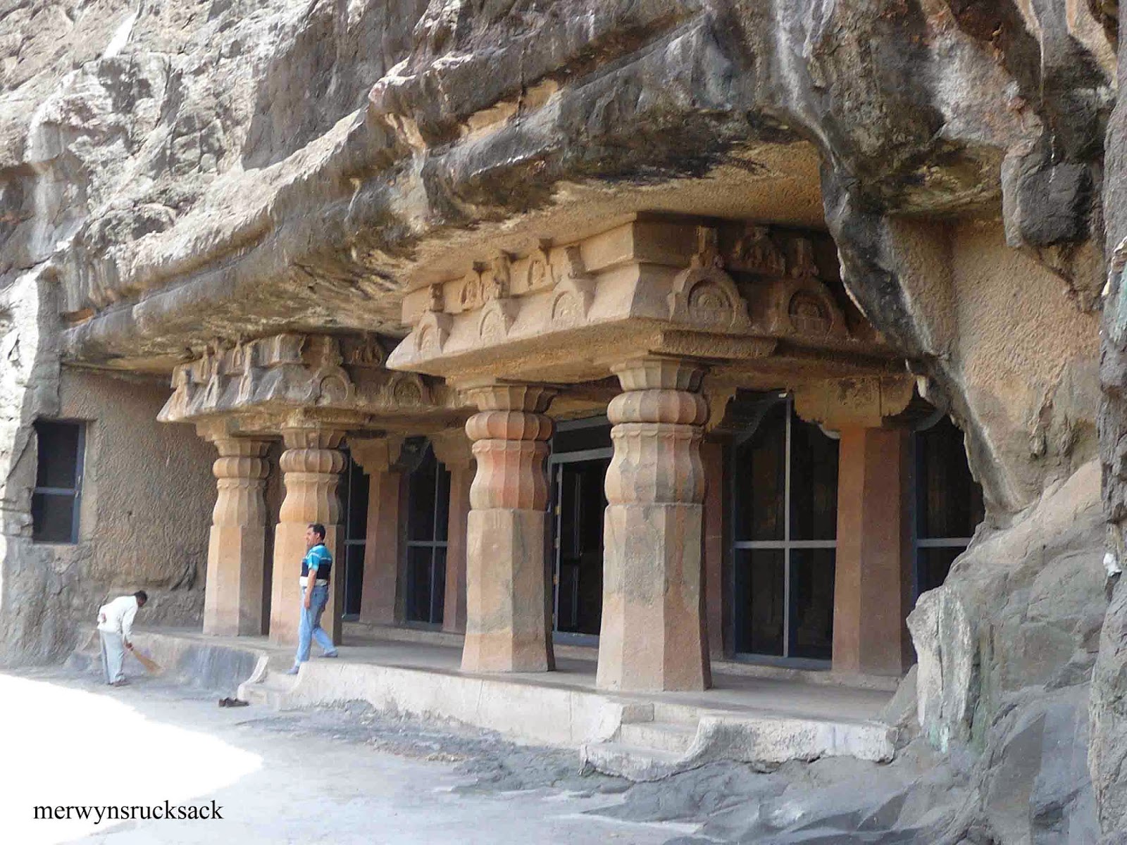
All the caves are beautifully carved out of the rock. Some had beautifully carved pillars in them along with carvings of Buddha on the walls and a huge Buddha sculpture carved in the middle. This was the phenomenon in all caves.

Some caves had paintings on the walls and the ceilings too. Imagine in that time they painted the walls and the ceilings and the paint has survived for centuries. Look at the paint which we paint our houses from the inside and outside, it needs to be changed every 5 years as it is spoilt by the heat and water leakages. Maybe the paint manufactures should go back in time and take tips from the monks who had painted these caves.
Caves
I like Cave.26 the most has it has a huge reclining statue of Buddha carved on the walls along with other poses of Buddha. It also has a stupa and many beautifully carved pillars in its premises.

Some of the caves were so dark and so poorly lit that it was difficult to take photos in it without using the flash, as flash was banned in the caves. Flash spoils the paintings on the wall hence no usage.

The good news is that drinking water is available on the cave premises and so are toilets available. These are usually missing all over the historic sites in Maharashtra.
Beautifully carved Stupa
Our guide told us that the Japanese Govt is investing in the up keeping of these caves. To this I was ”What, Why”, is it that our Govt has no money in the bank that they need to take the help of the Japanese to upkeep the caves. This is ridiculous as Maharashtra is the richest amongst all the other states and we still begging for help. That is ridiculous.
Carvings
I guess we are more interested in making money that the moment we found someone ready to invest we could not resist the offer. Any which ways it’s good that the caves are being looked after. Though we are late but still we can protect what remains.

The wooden bridge on the river Waghora, offers an amazing view of the Caves. If you have a camera with a 14mm wide angle then you can get the caves in a single shoot instead of sewing images together on a normal camera.
Carvings
A big thank you to the Japanese for investing in the up keeping of the caves. Though I didn’t like the nets that are placed at the openings in the caves. I guess the nets are placed to keep bats away from the caves that stay there and have droppings all over the caves. The caves are home to them, so I guess they should be kept the way they are.

I personally don’t like the new net covering for the caves. The same is spotted even at Ellora Caves located in Aurangabad.

It took us around two hours to see the caves.
Ajanta Caves
Again we boarded the Non AC bus to reach us to Ajanta Car Park from there we landed on the highway to board a ST bus to take us to Aurangabad.

Finally after travelling in the bus for three hours at 1600 hours we were at the City Bus Stand. Tired. Phew.

Popular Posts

Related Posts Plugin for WordPress, Blogger...