Search This Blog

Powai Lake

Thursday, March 29, 2012


Powai Lake is located in Powai, (where else?) and rests between the Renaissance Hotel on one side and the Hiranandani Gardens on the other. The closest railways station is Andheri on the Western line and Kanjurmarg on the Central line.
I had been planning to check out this lake for a long time. Finally I had made it here. Powai Lake is within Mumbai city limits and can be easily accessed by road.
The lake is so beautiful that when you see it in front of you, you will feel that you are out of the city, never mind the traffic jammed road behind you, with the vehicle horns blaring in your ears.

View of Powai Lake

I started to walk along the footpath cum garden which has been created around the lake so that people can enjoy the view of the lake. Most of the work is complete except for a few places along the way, but it is open to the public.
As I started my walking journey along the banks of the lake, I soon came across a machine showing the water level below and a sign warning people not to venture into the waters. I saw 13 of these installed all over the place so that people don’t venture into the lake.
There is another board there stating “Crocodiles inside the lake, do not enter the lake area.”

Another View of Powai Lake

In conversing with a frequent visitor to this place, I learned that a crocodile had been sighted here just a few days ago with its mouth wide open. He added that the crocodiles camouflage themselves well in the surroundings, so it is advisable to always watch out for them and not take any chances whatsoever.
But as the saying goes “Curiosity killed the Cat.” Some ignorant people still venture into the lake in order to catch fish. Apparently, Guppy fish are easily available there.
Is the love to catch fish so strong that people refuse to bother about the water level and the crocodiles inside? A point to ponder upon. I would definitely not do something like this when I know the danger involved in it. But people love to take risks, as the saying goes “Not taking a Risk is the biggest Risk ever.”

Yet Another View of Powai Lake

As I walked on the footpath I saw that the path was made of neatly cut rock stones like the ones they have on the streets of France. The feeling of walking over these stones is amazing.
I saw a few children playing on the mini merry-go-round, swings, and slides. A look of pure, unmitigated joy was evident on their faces. They were thoroughly enjoying themselves. When I was a kid, I don’t recollect going to some garden to play but I used to play in my building compound with my friends and the same joy, I remember, used to be visible on my face.
There are wooden benches put up near the lake so that people can enjoy the view of the lake. I saw this place infested with couples getting cozy by the lake, followed by oldies-goldies and the health conscious who come there for their evening jog.

Crocs in the Water

As I sat on the bench, I could see an amazing view in the water. There were a few bare and a few fully laden coconut trees standing in the water with their roots clearly visible as the water level was low and their reflection in the water made my photos even more realistic. The waves created on the waters lashing on the thick flora growing close to the lake and the flora swaying with the impact made an amazing view.
The reflection of the Renaissance Hotel painted white in the water and the tall skyscrapers in Hiranandani also presented a great sight. The view of the lake at dusk was amazing, followed by the street lights and the building lit up and the reflection of the same in the dark water was quite a sight to see.
Again I am bad at the names of flowers but saw some amazing flowers grown and pruned in the garden next to the lake.
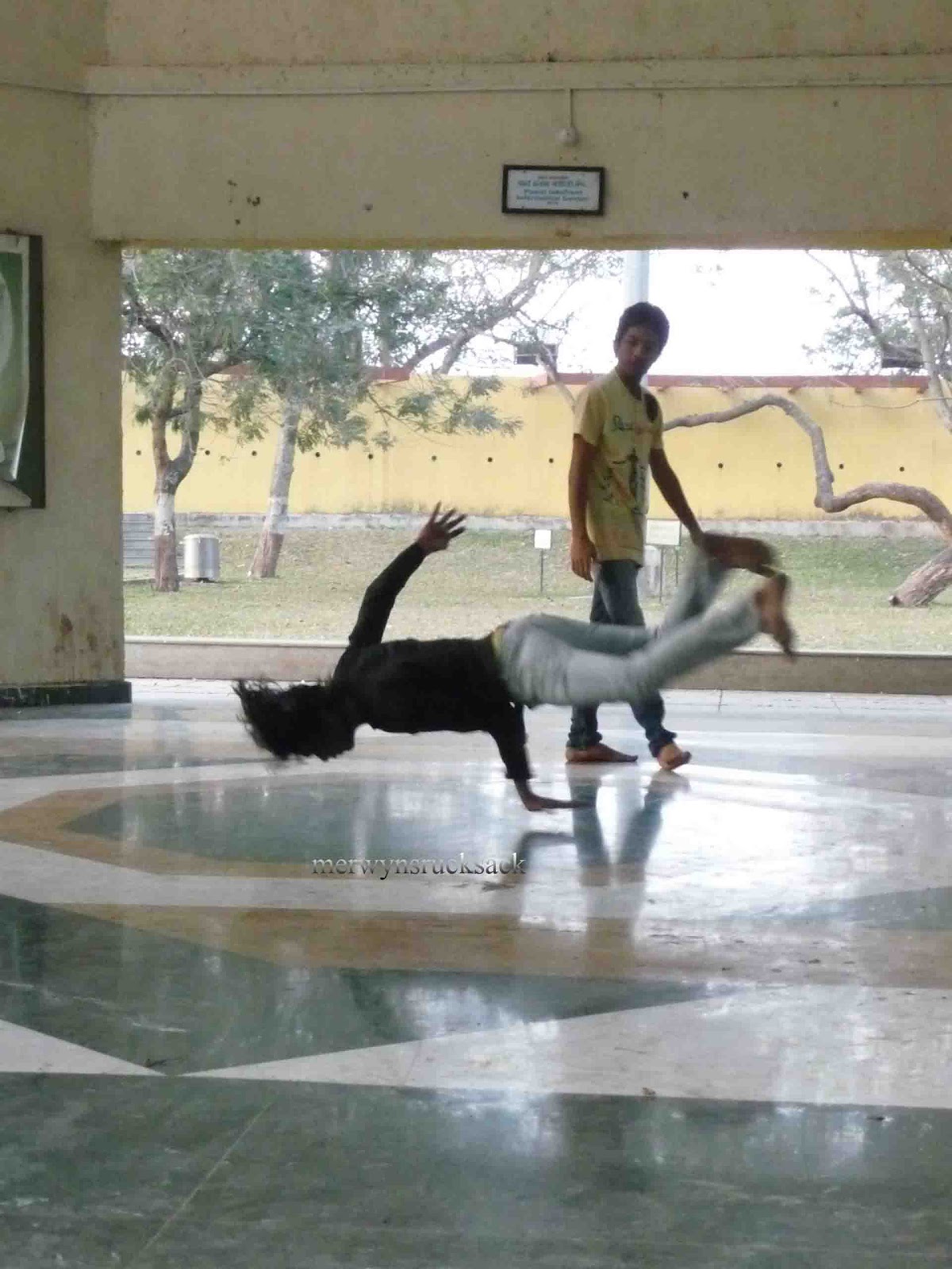
Freestyle Dancers

Next come the birds. I am bad at their names too; the only birds I know are crows, sparrows, pigeons and eagles. To the others I give a pass.
I saw three different kinds of birds here, I have photographed the same so if you know their names, you are welcome to enlighten me.
 Visitors to the lake can usually enjoy a boating service. For a fee, you can drive a boat in the crocodile infested waters. But didn’t see many takers for the same. I saw just 2 boats in the water.

Me

The lake is huge. There are gardens created on the side of the road near Hiranandani Gardens. The side of the lake visible from Renaissance Hotel is closed to non-hotel guests.
It was getting darker, and I saw a flock of birds flying in synchronization, forming a V shape and flying away. Maybe they were heading home as it was going to be dark soon. They were followed by another flock of birds, much smaller than the first. I guess they missed the first flight so the group was smaller.
I later entered the Powai Nisarga Udyan, which is a garden near the lake. It is enclosed but still open to the public. I caught hold of some new flowers there. There was a small hall, where some boys would regularly show up to show each other their dance moves, practice and then have a face off. As I saw them dancing “Step Up” is the movie which came to mind, it is all about dancing, face offs etc. I took their leave as I was not done with the lake.

Reflection Hiranandani in the waters of Powai
There is a musical fountain there open to the public. There are four shows of thirty minutes each. To my bad luck, there was no show that day.
After seeing this lake from the Hiranandani Gardens end, I decided to head back home, I had missed seeing the crocodiles and the musical water show, but nevertheless the journey was fun, as I had had the chance to converse with loads of new people and learned many new things about the place.
But what impressed me the most was that one look at the lake, and you could forget about the busy road right outside, It is truly a beautiful place in which to unwind after a hard day.

Hanging Garden

Monday, March 26, 2012


Recently I had a pleasant time at Hanging Gardens, also known as Pherozeshah Mehta Garden, and Kamala Nehru Garden, perched on the top of Malabar Hill. From here one can get a view of the Girgaum Chowpatty Beach, the Arabian Sea and Marine Drive, that shimmering stretch that is so well-known as the Queen’s Necklace. The closest railway station is Grant Road on the Western railway line.

Starting off from home, I bought a train ticket to Grant Road. As always, the trains were crowded. I had a tough time getting into the train. It was certainly very difficult. I alighted at Grant Road station. Since the last time I got off at Grant Road station, there have been a number of changes here. One major change that directly helped me was the construction of a skywalk, which connected directly to the overhead bridge connecting the east to the west. The bridge saved me a lot of legwork, I can tell you that.

Entrance to Hanging Garden

Skywalks have been built outside many stations in Mumbai, but I haven’t seen many people using them. They are mostly filled with couples, drug addicts and, you won’t believe this, even cows. I once saw a cow on the skywalk outside Andheri station on the east which connects to Gokhale Bridge.
Anyway, I certainly made use of the skywalk and reached Grant Road Bridge. I crossed over and walked on the right hand side. I came across two bus stops there. One of them caters to buses going to Kamala Nehru Park. Bus numbers 41, 42 and 105 ply to Kamala Nehru Park. Alternatively there are taxis and private vehicles that can take you there.
When I travel, I always prefer to use public modes of transport like trains, buses etc as I get an opportunity to interact with people. Plus you get to really experience a place.

View of Hanging Garden

I bought a ticket to Kamala Nehru Park at a cost of Rs.7. As the bus rumbled along the narrow roads, I saw many old buildings there had been built in the British era. I saw Wilson College, Girgaum Chowpatty. Now we were going up the hill and on my right-hand side, I could see a hillock behind the buildings. “Is that Malabar Hill?” I asked the bus conductor. He replied, “Yes.”
I noticed that the bus was going to Walkeshwar. I had been to Walkeshwar before when I visited Ban Ganga. So I inquired again with the bus conductor and he told me that the bus goes via Walkeshwar as there is no direct turn for buses and heavy vehicles on the way to Malabar Hill as the road is very narrow.

Flowers

Hanging Gardens and Kamala Nehru Park are directly opposite each other. I entered Hanging Gardens. There was no guard positioned at the entry point nor was there an entry fee to view the Garden.
I started my photography session with a bed of flowers there. The flowers were in white, light and dark pink shades and looked lovely amid the bed of green leaves surrounding them.
The park was really well maintained. A round of applause for the keepers of this garden.

Me amongst the Flowers

A memorial stone in the garden stated that the reservoir was laid in 1880 and was extended to hold 30 million gallons of water in 1921. The park is open from 5 am to 9 pm every day.
It was around 3 pm, and the garden was not so crowded. I saw a few couples who had come to spend some time in the park. Also a few families seemed to be out on a picnic. Most of them seemed to be out-of-towners who had come to see Mumbai. They were having lunch. It was certainly the most perfect ambience to enjoy lunch, sitting on the green grass below with the blue sky above and having your lunch surrounded by greenery. A few people were having a short nap.

Animals pruned out of the creepers
There were various types of flowers growing there. I immediately got busy with my photo session. There were flowers everywhere all around. For a moment I felt as if I was in a valley of flowers, somewhere outside Mumbai. The feeling of being one with nature was truly beautiful and I was making the most of it.

There was a watch tower in the garden which gave the time — the correct time. The garden was beautifully cut and pruned, and the green grass, the flowers and the bushes were a nice sight to see.

Old Woman's Shoe vs Me and my shoe

Bushes were trimmed in the form of animals. Creepers were made to grow at the entrances of mini gardens. These creeper doors looked quite nice as the creepers had been neatly trimmed.
The benches were vacant as it was afternoon. Some portions of the park were being redone, and I am assuming that the next time I am back; they too will be as beautiful as the ones that are currently on display.

Chowpatty Beach from Kamla Nehru Park

After shooting plenty of flowers, I decided to head to Kamala Nehru Park on the other side of the road.
Kamala Nehru Park is similar to Hanging Gardens in terms of the maintenance of the park. It is smaller than Hanging Gardens. Occupying an area of 4000 square feet, the park is named Kamala Nehru after the wife of the first Prime Minister of India, Jawaharlal Nehru.

View of Kamla Nehru Park

There is an Ashoka Chakra placed on a narrow cylindrical stand in the garden. A little ahead is a huge shoe, a storey tall, looking exactly like the boots I was wearing? This place is very popular for school picnics.
The shoe is known as the Old Woman’s Shoe. I had a tough time climbing up the spiral ladder. It was very narrow and I am huge, and of course the shoe is designed for small children to play in. Somehow I managed to climb up the ladder and then back down. The view from up was not that amazing. All you get to see is the garden in front. The shoe from the inside is subject to the graffiti of some losers who had been here, who have sketched their names all over the inside. Children of course aren’t bothered with such things, and they were having a grand time in the shoe.


Children in the Park

I then headed off to the stretch from where I got the best view of the day. I could see Girgaum Chowpatty beach with the water lashing out on the shore, a few fishing boats in the water, and the beautiful Marine Drive.
I then moved on to see the kids section of the Park. A board states, “Only for children below 12 years of age,” but I saw grownup boys playing on the rides here. In fact they broke it as they were playing.
After seeing these gardens in their entirety, I admired the way they had been maintained. Again a round of applause for the keepers of these parks. The walk in the park was nice and refreshing for me and I enjoyed myself here. I recommend this park to everyone in Mumbai.

Forts on Ghodbunder Road

Monday, March 19, 2012


Ghodbunder Road (commonly referred to as State Highway 42 or GB Road) is the connecting road between Borivali, Mira Road and Bhayander and Thane. It intersects the Mumbai-Ahmedabad Highway and cuts through the Sanjay Gandhi National Park.

I had been planning to see the forts on Ghodbunder Road for a very long time. But Internet exploration and conversations with other trekking groups had failed to yield any information about these forts.
All I knew was that they were located on Ghodbunder Road. I had never travelled on Ghodbunder Road. So I inquired with a few people and they told me that it would take me around an hour to reach Thane. The same people warned me that the road was very dusty.
A few days ago I chatted with Kiran from Wild Ventures and told him that I wanted to visit these forts on Ghodbunder Road. Kiran is a resident of Thane but was unaware of these forts. He immediately agreed to join me in exploring these forts. He too started gathering information as to the whereabouts of these forts and we shared the little information we had with each other.
We decided to meet at 8 am at Hotel Fountain, which is located at the intersection of the Ghodbunder Road and the Ahmedabad Highway. From there we were to explore the forts together on his motorbike.

Bastion on the Fort

I was all set for this trip. After months of asking people on the Internet, I was finally going to visit these forts.  I boarded the Borivali local at Andheri and headed to Borivali railway station.
From here I had many choices. I could board a BEST bus, an ST bus, rickshaw, private vehicle or walk it out.
The BEST bus stop is right outside the station. There are three buses that ply on the Ghodbunder Road, AS-700 AS, AS-458 AS and 700 Ltd. I could locate the bus stop for AS 700 AS, but there was a crowd waiting for that bus. I could not locate the other bus stops so taking my chances I decided to walk a little towards the ST bus depot located equidistant from Borivali station and the Mumbai Ahmedabad Highway.
Luckily I got an empty bus that was about to depart. I immediately boarded this bus. I bought a Rs 10 ticket to Hotel Fountain. This area is known as Versova Bridge. As I was not familiar with Ghodbunder Road, I asked the conductor and the passengers around to guide me to this stop.
The bus goes via Kashi Mira to Ghodbunder Road. This part of the journey was fun. The sun was rising slowly in the distance and the entire city was filled with fog. The view was a pleasant sight to see. As we turned onto Ghodbunder Road, it became chilly as the bus gained momentum. The greenery all around, the road with its twists and turns and the mining done at the shore were a pleasant sight to see and of course the driver driving the bus as if it was a formula one car. Vroom Vroom!

Versova Bridge

But my bus journey was short lived as I heard a voice saying, “Bhaisaheb, apka stop, Fountain Hotel aa gaya.” I thanked my co-passenger and got off the bus.
I was 10 minutes early. I called Kiran to make sure that I had alighted at the right stop. To which he said “Yes” and told me that he was on his way and would be there shortly.
Kiran arrived at 8.20 am. Apparently his bike tyre was punctured. That didn’t dampen our plans and we set out to see Ghodbunder Fort.
The road to Ghodbunder Road is exactly opposite Fountain Hotel. A small dusty road takes you to the fort. So started our journey. Now there are signal posts near this junction but as usual they were not functioning. One has to be very careful when crossing the road. We managed to cross and took off on the narrow road.
The road was very narrow and we had a bumpy ride. To top it all, the road was a bit slippery on account of the fog, but we managed to reach the village safe and sound due to the expert driving skills of Kiran. Kudos to him.

Hotel Fountain

We stopped at a tea stall to have some hot tea on the cold day. Since the temperature was low, our tea quickly became cold. Kiran informed me that he had around 22 years of experience in travelling and that of late, he had begun to organise camps and treks for the general public. I was impressed with his years of experience. We soon finished our tea and headed out again. It took us around 35 minutes to reach the village next to the fort.
The road is near the creek where dredging is carried out on a high scale. I guess this is the major activity here. The village was packed with small hamlets. We passed through them via the thin tiny roads. Finally we got to see a glimpse of the fort.
At our first fort, Ghodbunder Fort, we immediately parked the bike and set out to explore the fort. The fort, not too big, is a result of construction from two eras, which have yielded the new and old walls. According to Kiran, the old walls were a product of the 15th century and the new walls a product of the 17th century. He added that the fort was conquered by the Portuguese in the 17th century. No idea who was the ruler prior to it.
We walked through the fort. Some of the walls had beautiful arches like the ones I had seen in Vasai. Some attempt was being made to restore the walls to their past glory.

Old and New ruins on the Fort

There is a cylindrical structure about a storey high from where the view is amazing. It gives a good view of the village below, the creek nearby with the mining work carried out there, the mangroves in the distance and civilisation in the form of buildings cropping up in the distance.
We felt sad to see this so-called development. Kiran and I agreed that if we had come here 10 years ago, there would have been only mangroves around. Today there were buildings here. Who knows what will happen in the future. This fort on which I am standing might get demolished and a skyscraper might be standing here.
We shot a couple of photos here. Kiran said that at one time, there might have been a cannon up here to guard the fort. He said this based on the circular duct on the floor.
As we got down from there we saw two rectangular nets put up on a small ground in the fort premises. They looked like the ones that are used for batting practices in cricket.

Kiran and Me

I noticed that there was no graffiti in the form of names or any other words on the walls of the fort. This is a good thing, but probably because it is not visited by people and is fairly unknown. When it comes to our ancient heritage, anonymity is a good thing.
We then headed back to the village on the outskirts of the fort. Here we spoke to an elderly man who told us that there was once an underground tunnel that connected this fort to Vasai Fort. That tunnel is now buried.
We then inquired with him about the Nagla Bunder Fort and he told us that it was near Gai Mukh on the Ghodbunder Road and that there was a church up there. With this piece of information we set out to see the fort.
Again we headed back to Fountain Hotel and took off on Ghodbunder Road on our way to Gai Mukh. On the bike I noticed sign boards warning the public about leopards. Kiran said that leopards usually cross from one side of the jungle to the other and are usually spotted at night.

Fort Premises

Finally we got a glimpse of the church on the hill on our left hand side. We then figured out the road to take us there. A dusty bylane leads us to the Church.
I guess two hillocks have been demolished thanks to mining. And I could see another two headed for destruction. If we let mining continue, soon we will not have any hillocks left and the animals will not have a home soon and will be seen staying and living along with us in our cities.
Just imagine, a lion or leopard walking on the road or chasing us humans like dogs chasing cats. Where are we headed, is the question we need to ask ourselves. In destroying the homes of these animals, we leave them no option but to move to the cities. That is why we hear of instances of wild animals attacking people. It is humans who make inroads into their world. We are to blame for it.
Finally after travelling along the dusty road we reached the church. We couldn’t see the walls of the forts so we headed off to see what we could spot from up there.

Church at Gai Mukh
The church is very small and is named “Our Lady of Hope.” There were devotees praying inside. We set off to find out if we could find any remains of the walls of the fort. Kiran deduced that there might have been a fort here, based on the way the ground appeared. But the church itself looked quite old.
We then sat there in the shade of the compound to have our snacks; Kiran had brought egg bhurji (scrambled egg) which I ate with enthusiasm. As we had our snack we discussed our future plans.
After relaxing there for some time we headed off the Ghodbunder Road. From there I boarded a BEST bus to take me to Borivali.
As I sat in the air conditioned bus, I recollected all the adventures we had. We had discovered Ghodbunder Fort and Nagla Bunder Fort. I bemoaned the mining and dredging activities which were destroying the mangroves and urbanising the area.
Finally my wish of visiting these forts got fulfilled. Stay glued to my blog for more on hidden treasures our world has to offer.

Panorama Point in Matheran

Friday, March 16, 2012


This trek took place in the rainy season last year. It had been raining heavily for a couple of days, so my office colleagues and I decided to go on a trek to see some place in all its green glory.

We decided to go to Peb fort which is located near the hill station of Matheran. We gathered at Kurla station on the Central line and decided to board the last local for Karjat. We had to reach Neral station on the Karjat railway line.

Eight of us boarded the 1.07 am train at Kurla. We made a lot of noise in the train. Since this was the last train for the night, it was packed with people who later started alighting at their respective destinations. Initially we laughed and joked a lot, but then we began to get tired and started taking short naps as were going to reach Neral at 2.45 am.

Our plan was to wait at Neral station until dawn and then set out. A trek is no fun if you get lost in the dark, and we were here to have fun. We tried to sleep but the mosquitoes and the outstation trains with their sirens kept us awake. Finally we decided to make a move at 4 am.

Now we hadn’t carried any torches so our only hope was that the moonlight would help us to tackle the dark roads and that the rains would spare us.

But what is a trek if there is no adventure?


View from atop Matheran

No sooner did we step out of the station than it began to rain. The rains started playing hide and seek with us. It was very chilly.

We missed the electricity tower where we were supposed to take a detour and carried on in the dark night with no moonlight to guide us on. :(

Even after walking for around two hours we were still climbing. A few locals told us that in order to visit the fort, we would need to go along the railway line.

There are two ways to get up Matheran. The road takes you up in 30 minutes’ time though the climb is very steep and the mini-train takes around 2 hours. So if you have lots of time to spare, then you can certainly take the rail route.

The railway line is closed during the rains for fear of landslides. The line had already been closed a week when we got there.

Trekking to Panorama Point via the railway line

On this trek we got to travel by both the road and the rail route. At indicator 135 NM we boarded the railway line and decided to walk along the stretch. We walked for two hours and all we saw was the track ahead and the scenic view around. By this time the sun had risen and the rays were breaking the clouds and falling on the face of the earth. It was a beautiful sight to see.

I immediately got my camera into position. At which point my fellow-trekkers began to pose for pictures and cribbed loudly about my unwillingness to click their snaps. I had to remind them that I had brought the camera along to shoot nature pictures.

Finally there was a sign there indicating the way to Peb Fort, which apparently is now on a different hill range altogether. We were very pleased to see it. On the Peb hill range, I could see a temple with a table like structure in the distance.

Kadyavarcha Ganpati

We saw the access route to the fort. It seemed difficult to cross, but promised adventure. We decided to head to Matheran as the track would take us there. On the way there was an entrance to a temple. But we could not locate any temple.

The entrance had a bell and had a series of steps leading somewhere. We didn’t follow the steps to see where they were leading to. I wanted to go, but most said NO so I obeyed the majority and we decided to head atop to Matheran.

After walking for around 30 minutes we were taken by surprise by something we saw on the left hand side. There was this huge statue of Ganpati (standing erect) painted on a rock surface with a rat at his feet. This is known locally as Kadyavarcha Ganpati, as it is on the corner of the hill.

Panorama Point
The statue was around 2 storeys high and looked stunning even from a distance. Then we realised that perhaps the steps near the temple led to this place.

After walking and enjoying the scenic view we reached the entrance of Matheran. It was 10.30 am. We had a few refreshments there and decided to visit Panorama  Point, the highest point on Matheran. We walked through thick vegetation and finally landed at Panorama  Point. Most of us were dead tired as we had walked for almost seven hours at a stretch to reach here.

Atop Panorama  Point we could see Peb Fort in the distance and the Ganpati too. It was just awesome. After that we boarded a jeep which took us down to Neral station within 30 minutes. I was back home at 2:30 pm. This was certainly my shortest trek ever.

Erangal Jatra

Friday, March 9, 2012


Ever since Shawn and Flature had told me about this Fair which takes place at Erangal Village at St Bonaventure Church, I had made up my mind that I would go see this Fair. I go to the Bandra Fair every year. But this fair was new to me.


 The Erangal Fair is held every year on the second Sunday in January. To read about the Erangal Church and Village   http://merwynsrucksack.blogspot.in/2011/12/madh-fort-erangal-village-and.html
St. Bonaventure Church
I had gone to visit Matheran with Shawn, Perpetua, Savio and Flature on Saturday. To view my writeup on Matheran, click on this link, http://merwynsrucksack.blogspot.in/2012/03/matheran-four-points-and-lake.html

The relentless walking that we had done in Matheran had caused blisters on my leg but I didn’t want to miss the Erangal Fair. So despite my foot injury I decided to go to the fair.


 I asked Hithakshi to accompany me to the fair. We decided to meet at Malad Railway Station at 2 pm. As it was a Sunday, the frequency of the train services had been affected on account of maintenance work. We were able to reach Malad station only at 2:30 pm.
THe Erangal Jatra on the Beach
Bus no. 271 plies to Madh. Since Erangal Village is on the way to Madh, we boarded this bus. On this day BEST runs special buses to take devotees to the Church. Each bus carries a banner, reading Erangal Jatra - Reserved especially for the Fair (Jatra). The bus ride lasted for 35 minutes and cost us Rs 12 per head.


 At the bus stop, there was a big traffic jam, with police bandobast (police for patrolling the fair) and devotees in large numbers.


Giant Wheel
We added our numbers to the crowd. Both sides of the road were crowded with vendors selling sweets, toys, curtains, religious articles and foodstuffs. It took us around 20 minutes to reach the Church.


The church, built in the 15th century, was whitewashed and beautifully decorated both from the inside and outside with lighting and other décor.
Statue of St. Bonaventure in the Church
Statues of St Bonaventure were kept for people to pay their respects. People came in huge numbers to pay their respects here. We too joined them in the queue.


The Church is near the shore and as it was a time of low tide, the waterline was far away. It was the perfect opportunity for vendors to set up their stalls.


The Well of Death
Flature had left a comment on my earlier post on Madh Fort, Erangal Church and Mandapeshwar Caves that the fair was usually meant for East Indian communities who used to cook, play music and eat in the shacks they used to build on the sea shore. But that was the past.

To view my post on Madh Fort, Erangal Church and Mandapeshwar Caves, click on this link http://merwynsrucksack.blogspot.in/2011/12/madh-fort-erangal-village-and.html


As I entered the Fair (jatra) I was reminded of the depiction of fairs in old Hindi B&W movies that I used to see as a child. This fair was exactly like those shown in those old films.


Local Tattoo Artist
The tall giant wheel ride, the merry-go-rounds, and small car rides for the children, the Well of Death where daredevils drove their cars and bikes, the ice cream and cold drink stalls on the beach, the toys prepared by the local artisans, the tattoo artists with their tattoo machines and designs, the clothes kept for sale on the beach, the sweet marts, toy shops, the balloon shooting galleries – all these things took me back in time.


There were horse carts too on the beach, where people were enjoying joyrides for a price.


The Erangal Jatra


As we walked through the fair, we saw a number of people sitting about in small shacks and listening to songs played on their car stereos while eating food cooked on a slow fire. These family get-togethers were a nice sight to see.
Later we headed off to the rocks to enjoy the cool breeze. We sat there and enjoyed the quiet sea and the huge crowd in a distance at the fair and later decided to head back as that was the only way in and out of Erangal Village. 
Families enjoying on the Beach


The bus stops were extremely crowded so we decided to walk for a while. Before long, we noticed that other people were also doing the same. We walked for a long time, without sighting an empty bus or rickshaw. Finally having walked for two hours we reached the junction from where one road goes to Manori and the other to Madh.
 At this point my legs began to protest against the strain they were being subjected to, but I could not indulge their need for rest. I still had to walk to get to some mode of transport. We decided to go to Manori and catch a bus there. Apparently the other people who were walking also had the same idea, because they all landed up at Manori.   
BEST Bus to Erangal Jatra
Now it was around 8 pm. We sat on the banks of the Manori Creek enjoying the view of the Pagoda in the distance. It was truly amazing. There was darkness all around with just the Pagoda shining as if it was made of gold.
 We had no luck with buses and rickshaws even at Manori. So we decided to walk to Malad station. It was a 1½-hour journey on two feet. To add fuel to the fire there was a traffic jam along the road, which made the movement of vehicles and humans difficult. As motorists started clambering on the footpaths, we humans found it increasingly difficult to walk.
 At last after walking for about 45 minutes, the traffic jam showed signs of moving so we immediately hopped on to a bus and reached the station in 30 minutes.
 I was extremely tired with all the walking and the blisters on my leg didn’t make matters any easier for me. Finally we boarded a train and headed home.
 In spite of the pain, I still enjoyed the jatra a lot. It brought back old memories.
 Thanks, Hithakshi, for accompanying me on this trip.
Map to St. Bonaventure Church from Malad Station


View Larger Map

Matheran (Four Points and a Lake)

Tuesday, March 6, 2012


This trip was special to me as it was the first one that I had organised under the banner of merwynsrucksack the adventure co. I decided to go to Matheran as it was close to Mumbai and promised to be an easy trek.
I put up an announcement regarding my upcoming treks on my blog to see if anyone was interested in coming along.
Shawn signed up along with his wife Perpetua and a cousin, Savio. Shawn had earlier accompanied me on my trip to Madh Fort, Erangal Village and Mandapeshwar Caves. You can check out that post HERE. http://merwynsrucksack.blogspot.com/2011/12/madh-fort-erangal-village-and.html
Flature, who had never gone on a trek before, also joined us.

Group Pic - Savio, Shawn, Perpetua, Me and Flature
As planned, we decided to board the 7.03 am train to Karjat from Dadar on the Central railway line. Matheran is a hill station which can be accessed from Neral station, two stations prior to Karjat. Alternatively you can also get there from Panvel, but this route is a bit difficult, so most people opt for the first route.
The train was 10 minutes early. Luckily Shawn and his party were in time to board the train. They managed to board the bogie next to the one Flature and I was in. Later at the next station they got into our bogie.
Our bogie was crowded, and everyone was loaded with bags.  I guessed that they were going for an outing, either a day trip or an overnight trip. And all were having fun in their groups. Luckily we got a place to stand near the entrance of the bogie, where we made ourselves comfortable, in spite of the crowd.
I was hoping to get a good shot of the sunrise, but the train was moving so fast that I could hardly get a clear shot. I needed to take many pictures before I finally got a good shot.  Yippee.  
Matheran
As we were standing at the entrance of the compartment, we could feel the cold wind against our jumpers and monkey caps. The winds were so strong that they penetrate through our woolen gear and made us shiver from within.

Finally at 8.40 am we alighted at Neral station. Half the compartment exited with us. Moving through the crowd, we got on the overbridge that would take us outside the station.
Matheran is clearly visible from Neral, as you travel towards Karjat,. It can be sighted on the right hand side. As it was broad daylight we could see the hill range. If you travel at night, the only way to recognise the hill range is by spotting two street light poles up at the entry point to Matheran.
There are four ways you can reach up here, mini train, cab, private vehicle and by walking.
View on the way to Garbut Point

I don’t know the price of the train ticket but I know that it takes 2 hours by train to reach Matheran and the station is near the Market area. But the view from the train is amazing, much better than the road view.
The Taxi stand here is very well organised. Each taxi accommodates 5 people. The cost of each seat is Rs.60. The arrangement is such that two passengers sit with the driver and the remainder sit on the back seat. The person sitting next to the driver sits in a weird position with the gear box right between his legs.
There was complete chaos at the taxi stand when we got there. Our driver had been given a receipt to take us up the hill, but we couldn’t locate him. We thought we had lost him in the crowd. As we were trying to locate him, far away in the distance we saw a hand waving out to us and then calling us. That’s our ride, yelled Shawn and we went on to board his taxi.
The taxis are mostly Maruti Omnis. For those of you who live outside India and are unfamiliar with this vehicle, let me inform you that it looks like a rectangular box on wheels. It is not a very comfortable ride but it is the only way up if you don’t have a vehicle. The other option is to trek it up. It is a 3-hour climb up to the entry point to Matheran, which is Dasturi Car Parking.

Toy Train to Neral from Matheran

The roads are not in good condition but they are not bad either, though bumpy rides are guaranteed no matter how powerful your vehicle’s shock absorbers may be. The taxi will take you up the winding roads with the hill on one side and the deep valleys on the other. On the way the road was so steep that the driver had to switch gears to climb the hill. Finally after 30 minutes we were up the hill.
We immediately decided to have breakfast at the entrance, at Dasturi Naka. Here we were welcomed by monkeys. Their number kept increasing. After a few photo sessions with the monkeys we decided to go have our breakfast at a small joint outside the entrance.
This place is very small and it serves omelet pav, vada pav, tea, packaged water and packed snacks and biscuits. No coffee is served here, sorry coffee lovers. Inside all over the place there are instructions put up stating “Self Service.”
As we were the first to enter we immediately placed our orders for 5 omlette pavs (a pav is a loaf of bread) and 4 teas. Flature did not want any tea.

Me at Garbut Point

Soon after we arrived it seemed as if the hotel was suddenly bustling with people. The owners of the hotel should thank us, as we gave them so much business. We had our omelet pav and tea and headed off to Matheran.
While making the omelet, the cook asked us if we wanted chillies in our omelets to which we all readily agreed. It was only later that we found out that all the chillies were in the omelet which was served to Flature.
After having our breakfast we headed off to buy our entry ticket to Matheran at a cost of Rs.25 per head. At the entry we were given a map of Matheran with the points and places to see in Matheran.
No vehicles are allowed in Matheran. The only modes of transport are walking, horseback and hand cart. Though there is an ambulance up there in case of emergencies.

View from Garbut Point

You can hire horses and go up to see the points, but only the famous ones will be shown to you. If you plan to see all the 33 points up here then I guess walking would be the best option and a trip of 2 to 3 days is required to cover Matheran in its entirety.
The roads are all muddy and dusty. The moment a horse passes by dust rises. The place is covered with red soil. In the rains, the ground gets rather mucky and wet. For a change it was not at all cold up here. The weather was pleasant.
We set off to see Garbut Point. This point is isolated like the Panorama Point in Matheran. It is a good 1½ hour journey to Garbut Point passing through the jungles and the edges to reach this point. Finally we were here.
The view was amazing; we could see Matheran i.e. the market area of Matheran at one end and many other hill ranges. Just the five of us were here. We were totally isolated and the feeling of being on top of the world gripped me.

Hamlets below the Gabut Point

From there we could see another village a few feet below on another hill range with an access road from there. Someday I’ll go camping there, I thought to myself.
After a few photo shoots we headed off the Market area. Again it took us another 1½ hours to reach the Market. Market area, as the name goes, means a place where everything is available, i.e. footwear, fast food joints, crafts etc and places to stay.
As it was lunch time we headed off to Gujarat Bhuwan Hotel, to have our lunch there. As we were going to do a lot of walking I chose this place as it serves unlimited veg thali for just Rs. 200. But the timings are 1130 hrs to 1400 hrs.
Our lunch consisted of 3 vegetables, dal, rotla (type of chapati), puri, rice, papad, and samosa and fruit salad, unlimited servings. The food was very good. We enjoyed it.

Flying Fox at Echo Point

We then set out to see the other points nearby. All the points are far away from one another. It is to be noted that all of Matheran cannot be viewed in one day. But it was ok. We then headed off to see Echo Point.
One the way to Echo Point we met another school friend of mine, Hansel who happened to be Flature’s first cousin. He had come there with another friend. He told us that they had trekked for 3 hours from Neral to Matheran.
The view is the same from most of the points; it’s just the angle which changes, but if you love hills and panoramic views then you will surely enjoy Matheran.
The locals have put up flying fox, valley crossing and Burma Bridge facilities all over the place. But the rates charged are extremely high. I don’t think the ride is worth the cost. But for first timers it ok if they want to do it.

View from Echo Point

There was a huge crowd at Echo Point. People were trying to see if their voices really did echo. We passed up the opportunity and walked on the edge of the cliff to reach Charlotte Lake. We walked on the dam. The water level was quite low. During the rainy season, the water overflows from the dam into the valleys below.
After crossing the dam we went on to see Lords Point. The view from here was also good. There were some rowdies here, who were a competition to the monkeys as they kept swaying from the trees for their photo sessions.
On the way we kept ourselves refreshed by having lemon juice. The locals charge extremely high for the same. We had one at a price of Rs. 20 per glass. But it was ok, need of the hour.
After inquiring with the locals we headed off to see some more points. It was around 4 pm. As it was winter when we visited Matheran, we knew that it would get dark by 6 pm. That meant that we had only another 2 hours at our disposal. Then we would have to head to the market. There are no street lights in Matheran other than the market area.

Charlotte Lake

We walked and walked, to meet a group coming from the front telling us that they couldn’t locate any point and so they had turned back. That did not dampen our spirits and we headed off to see the points. After about 45 minutes we reached Belvedere Point. We checked the same on our map to find out how far we were from the Market area.
Again we were rewarded with an amazing view of the hill range all around. Quickly we moved ahead to see the other point at One Tree Hill.
One the way to One Tree Hill we met two foreigners on horseback who overtook us. One Tree Hill is beautiful. It is a very small hillock on the edge of the cliff with one tree on it. I saw the hill and thought that no one could climb up there.
But I was wrong. One of the foreigners who had overtaken us climbed up there; though it was steep she still managed to go up there. What was mind blowing was that, she was dressed in a kurta, and wore glares on her eyes and chappals on her feet. And she carried a handbag. Later she told us that climbing up was easy, but while getting down she had to rely on her rock climbing skills.

View from Lord Point

She told us that just a small patch of rock was difficult on the way. None of us dared to follow in her footsteps. Savio and Flature were keen to go, but we dissuaded them as they didn’t have any rock climbing skills. I told myself that the day I learned how to do rock climbing, I would come back here.
Finally after covering One Tree Hill we decided to head back to the Market area as it was 5.30 pm. After walking for an hour we were finally at the Market Area.
Perpetua, Shawn’s wife, was tired from having walked for 7 hours and so she along with her husband Shawn and Savio decided to stay back. We respected her decision and Flature and I headed off to Dasturi Car Parking.
Now it was dark and we didn’t have any torches with us. But it was a full moon day so we went off to the car parking area under the moonlight. We walked to the train tracks as we were under the impression that the trains don’t ply at that time.

View from Belvedar Point

All of a sudden we heard the sound of engines. We wondered where the sound was coming from. Suddenly we saw the train approaching us and we stood by the side to watch the train go by.
Soon we were at Dasturi Car Parking and from there we boarded a taxi to Neral station. Again within 30 minutes we were down. We picked up some food and water for our journey back to Mumbai.

One Tree Hill
Up there we had seen Garbut Point, Echo Point, Lake Charlotte, Belvedere Point and One Tree Hill. Though it took its toll on our legs we still enjoyed the trip.
Thanks to Shawn, Perpetua, Savio and Flature for making this trip a memorable one.

Popular Posts

Related Posts Plugin for WordPress, Blogger...